Foreign Policy Blogs

NASA Image of the Day: Arctic Sea Ice Extent

seaicenasa

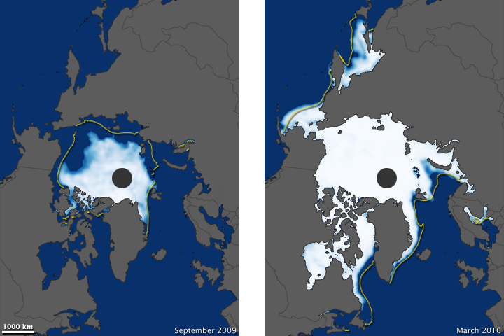
The NASA Earth Observatory Image of the Day is of the Arctic Sea Ice Extent from 2009 to 2010. The image on the left is from September, when the sea ice usually reaches its minimum. On the right is the sea ice maximum for the year, which usually occurs during the month of March. Sea ice peaked on March 31, the latest peak in the satellite record, which dates back to 1979. Strong winds over the Bering and Barents Seas generated a renewal in the sea ice formation late in the season.

At first glance, the ice appears to have not declined that much in the winter image. What the image doesn’t reveal, though, is ice thickness and age. The ice is thinner and younger than before. A few of the many consequences of this are that polar bears have a harder time fishing, while ships might have an easier time navigating.


Author

Mia Bennett

Mia Bennett is pursuing a PhD in Geography at the University of California, Los Angeles (UCLA). She received her MPhil (with Distinction) in Polar Studies from the University of Cambridge's Scott Polar Research Institute, where she was a Gates Scholar.

Mia examines how climate change is reshaping the geopolitics of the Arctic through an investigation of scientific endeavors, transportation and trade networks, governance, and natural resource development. Her masters dissertation investigated the extent of an Asian-Arctic region, focusing on the activities of Korea, China, and Japan in the circumpolar north. Mia's work has appeared in ReNew Canada, Water Canada, FACTA, and Baltic Rim Economies, among other publications.

She speaks French, Swedish, and is learning Russian.

Follow her on Twitter @miageografia