
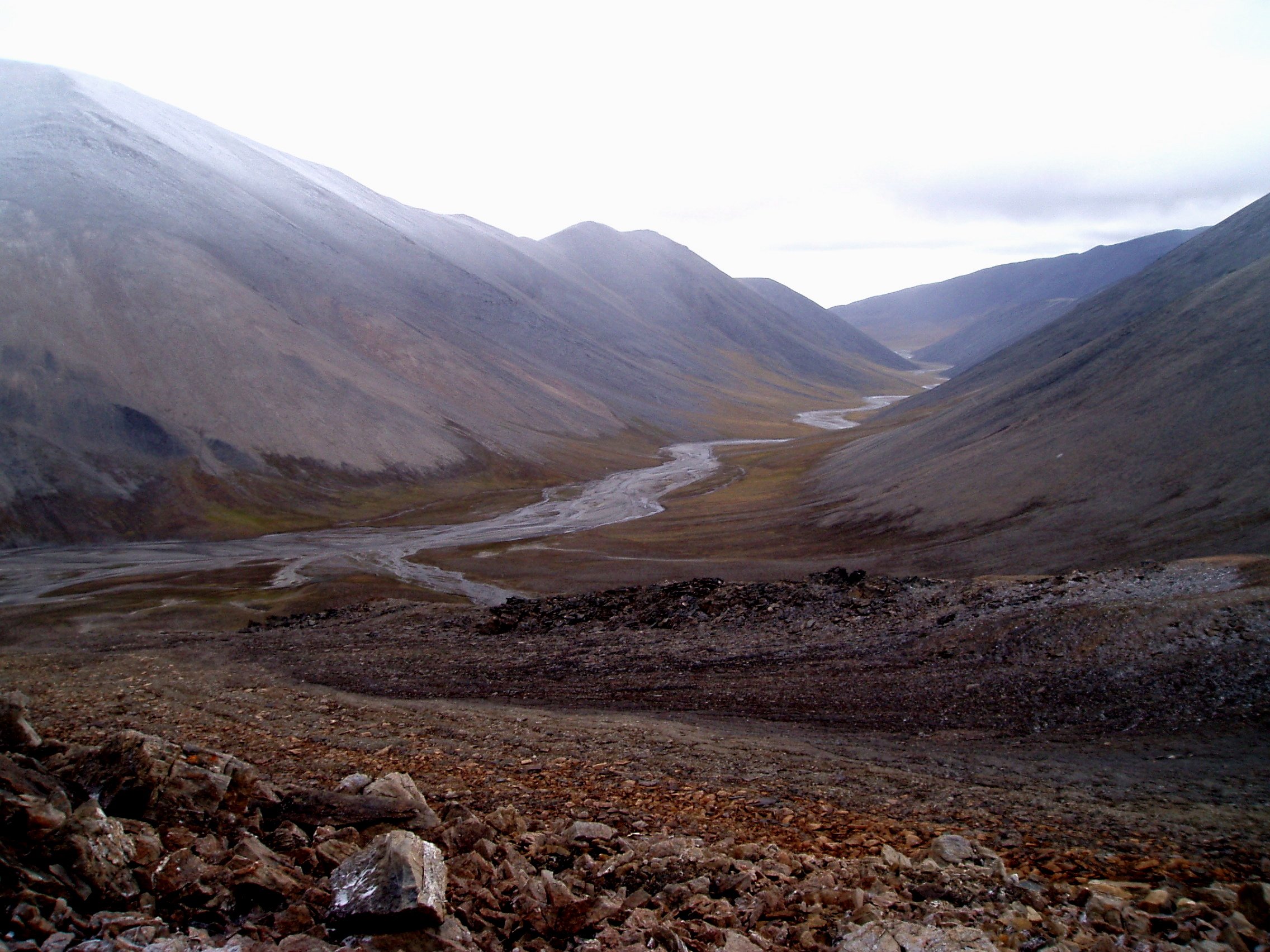
The Kishnikov (Predator) River on Wrangel Island. (c) Elizabeth Miller, Stanford University.
On December 27, Russian Prime Minister Dmitry Medvedev signed a decree creating a new buffer zone around Wrangel Island in the Arctic. Wrangel Island and nearby Herald Island have enjoyed environmental protection since 1976, when the USSR declared them to be state nature reserves (zapovednik, in Russian). Wrangel and Herald Islands are the only parts of the Arctic that constitute a UNESCO World Natural Heritage Site. Wrangel Island was named after Baron Ferdinand Petrovich von Wrangel. Born into a Baltic German family, von Wrangel led a storied life as a Russian Arctic explorer, naval officer, governor of Russia’s colonies in Alaska, and head of the Russian-American Company. The largest national park in the U.S., Wrangell-St. Elias, was also named after Baron von Wrangel. There’s even a Wrangel Island off of Estonia named after him.
The new decree aims to further protect the ecosystem of the two Arctic islands, particularly with regard to marine mammals like polar bears and migratory Pacific walrus. The decree also seeks to “ensure the long-term environmental security in the Chukchi sector of the Russian Arctic.” The key term here is “sector,” as the islands do not just exist in isolation. Rather, they strategically fit into a larger part of the Russian Arctic that includes the Northern Sea Route. When the state nature reserve was first established, the waters were protected five nautical miles out from land. In 1997, the distance was extended to twelve nautical miles, and in 1999, the protected zone grew to stretch 24 nautical miles out to sea. Yet in 2009, the 12-mile extension was cancelled by the Governor of Chukotka due to a “mismatch with Russian regulations,” although I haven’t been able to determine the exact nature of the “mismatch.” It’s important to see the entire Arctic as interconnected, too. Due to the way the ice drifts, the area around Wrangel Island is particularly sensitive to what happens in the North American Arctic. So, if an oil spill were to occur off the waters of northern Alaska, the toxins could drift across the Bering Strait over to the Chukchi Sea.
The new buffer zone does two things. First, it reestablishes the 24 nautical mile buffer zone, which UNESCO recommended that Russia do. Second, the buffer zone covers the waters off the southern part of Wrangel Island between the mouth of the Predator River and Cape Hawaii, which were not included in the 1997 extension. As an explanatory memorandum prepared by the director of the Wrangel Island Federal Reserve, Alexander Gruzdev, and the Deputy Director for Science, Nikita Ovsyanikov, states, this area was originally omitted from protection because of the existence of Ushakovskoe, a settlement which used to serve cargo ships. The Soviets also maintained a military presence here, with a radar station built at Cape Hawaii. However, navigation ceased in 1994, and the majority of the village’s inhabitants were forced to relocate in 1998. As a somber footnote to the story of human settlement on Wrangel Island, the last remaining villager, Vasilina Alpaun, was mauled to death by a polar bear in October 2003. The only people still living there are park rangers, so there is no longer any economic reason to exclude the surrounding waters from environmental protection. The area around Ushakovskoe badly needs rehabilitating, too, as I discussed in a blog post in July 2011.
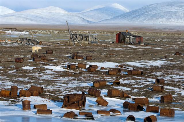
A polar bear roams through Ushakovskoe. (c) Sergey Gorshkov
The primary reason for creating the buffer zone is to protect the fragile and unique environment of Wrangel and Herald Islands, but Russia also has an economic interest in their conservation. First, the memorandum identifies ecotourism as one of the most promising sectors in Chukotka. Since 2011, Russia has been exploring how to promote ecotourism on the two mountainous outcroppings of land between the Chukchi and East Siberian Seas. The memorandum rightly identifies, though, that as ecotourism increases, the hazards posed to animals from a higher amount of boats and other vessels ferrying visitors do, too.
Second, and more importantly for strategic concerns, the protected sea area and buffer zone around Wrangel and Herald Islands has “geopolitical significance,” according to the memorandum. It will “allow better control of the traffic of ships along the Northern Sea Route.” The Ministry of Transport will help manage the buffer zone. It will also post a “Notice to Mariners” regarding the limitation of navigation in these protected waters. As the map below illustrates, the islands are just north of the typical path taken by ships through the Northern Sea Route. Russia’s move to further protect the waters around Wrangel and Herald Islands is in line with the overall state effort to standardize, regulate, protect, and codify the waters along the NSR. This, in turn, forms a key part of the government’s general strategy of enhancing state sovereignty in the Russian Arctic. The 12-mile zone around the islands falls within Russia’s territorial waters, while the entire area between the islands and the Russian mainland, between which the narrowest distance is 87 miles, form part of the country’s exclusive economic zone.
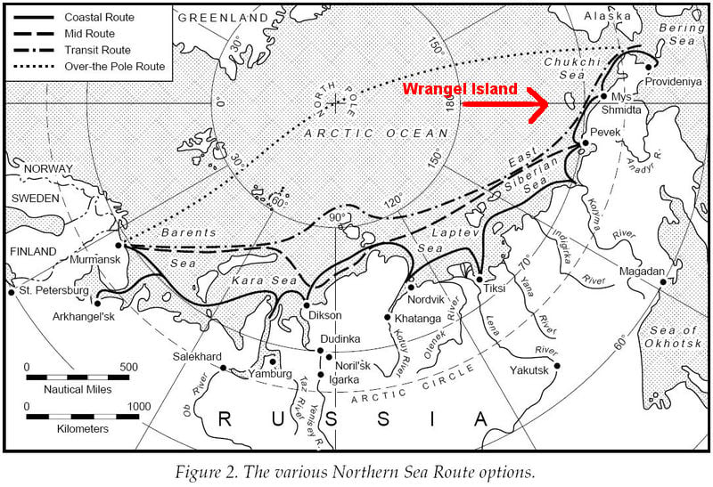
Wrangel Island with respect to the NSR.