
“Maps are ideology,” Christopher Connery, a professor of world literature and cultural studies, once wrote. If that is the case, then the map produced for the 2013 Arctic Frontiers conference by Reibo, an agency in Tromsø, Norway, is certainly an interesting case study.
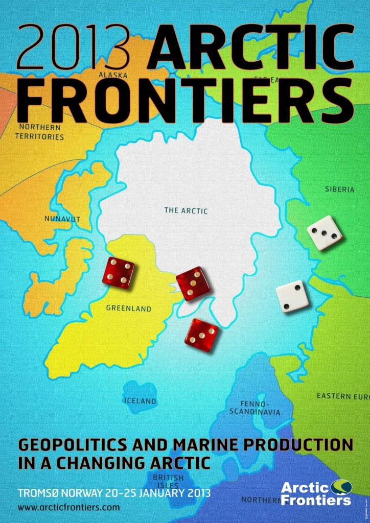
The colorful, stylized, and cartoonish map is not divided into countries, but rather into various regions with unusual place names. Not only are the names unusual, though: even the locations in which the boundaries are drawn is contentious.
The United Kingdom and the Ireland are represented as one entity, the British Isles, which I reckon would upset many people on both sides of the Irish Sea. The UK has a history of polar exploration and a real interest in the Arctic, as represented by the military, the Parliamentary Environmental Audit Committee, and the Polar Regions Unit. (As an aside, Duncan Depledge explored UK interest in the Arctic in more detail today during his presentation, which you can listen to here). By contrast, I’m not aware of Ireland ever expressing any strategic interest in the circumpolar north.
Iceland is the only country that has its own name on the map. Yet the color used to represent Iceland, a light shade of indigo, is the same as that used for Fenno-Scandinavia, which includes Norway, Sweden, Denmark, and Finland. This much is generally accepted in common geographic parlance, yet Denmark is a different color than Greenland. In this map, the autonomous island loses its Scandinavian association and connection with Denmark, highlighting the separation between the two parts of the Danish Kingdom. (The Faroe Islands, the third part of the Danish Kingdom, are noticeably absent from the map.) Instead, Greenland is symbolized as having closer ties to its west, with parts of Nunavut just across Baffin Bay painted a similar shade of yellow. Nunavut and west Greenland do indeed share many historical links through the Inuit people, who have settlements on both sides of the bay. The links also extend to ecology and conservation, for in the 1980s, there was talk of twinning Ellesmere Island National Park Reserve (now Quttinirpaaq National Park) and Northern Greenland National Park, though the plans didn’t come to fruition. This map ideologically reconnects both sides of Baffin Bay while distancing them from their respective southern capitals, Ottawa and Copenhagen. To the west of Nunavut are the so-called “Northern Territories,” which bizarrely subsume both the Northwest Territories and Yukon. Alaska is given its own name on the map, though the United States isn’t mentioned by name at all. The artist also took a lot of leeway in depicting the extent of the Alaskan panhandle, which looks significantly wider than it actually is.
Let’s turn to the map’s illustration of the Old Continent, which divides it into Northern Europe and Eastern Europe. There isn’t really any coherence to Northern Europe as a group geographically, politically, or otherwise. Even when it is used, such as by the United Nations, it tends to include the Nordic countries, the Baltic countries, and the United Kingdom and Ireland. Yet on this map, the designation of Northern Europe has shifted southward to the continent, covering everything from France to Germany to Ukraine. Eastern Europe seems to have shifted eastward, stretching from Russia’s western boundary with the Baltic countries to the Urals. Past the Urals is the vast landmass of Siberia, and to the east of that is the Far East. This distinction between the two regions conjures up a more Asian association for this distant corner of Russia, hearkening to the growing interests of China, Japan, and South Korea in the Arctic, along with their close proximity to the likes of Kamchatka and Magadan. It is also unusual to divide Russia into three parts. Even in Moscow, I would venture that traditional representations of Mother Russia see the Urals as splitting the country into two halves: the Europe-oriented west and the endless hinterlands of Siberia.
The name of “The Arctic” is given to the ice cap. The meaning of the Arctic is always up for debate, but here, it just seems to mean the quickly shrinking mass of ice on top of the globe. This is the area that some see as a global commons, while others see it as potentially part of their continental shelves.
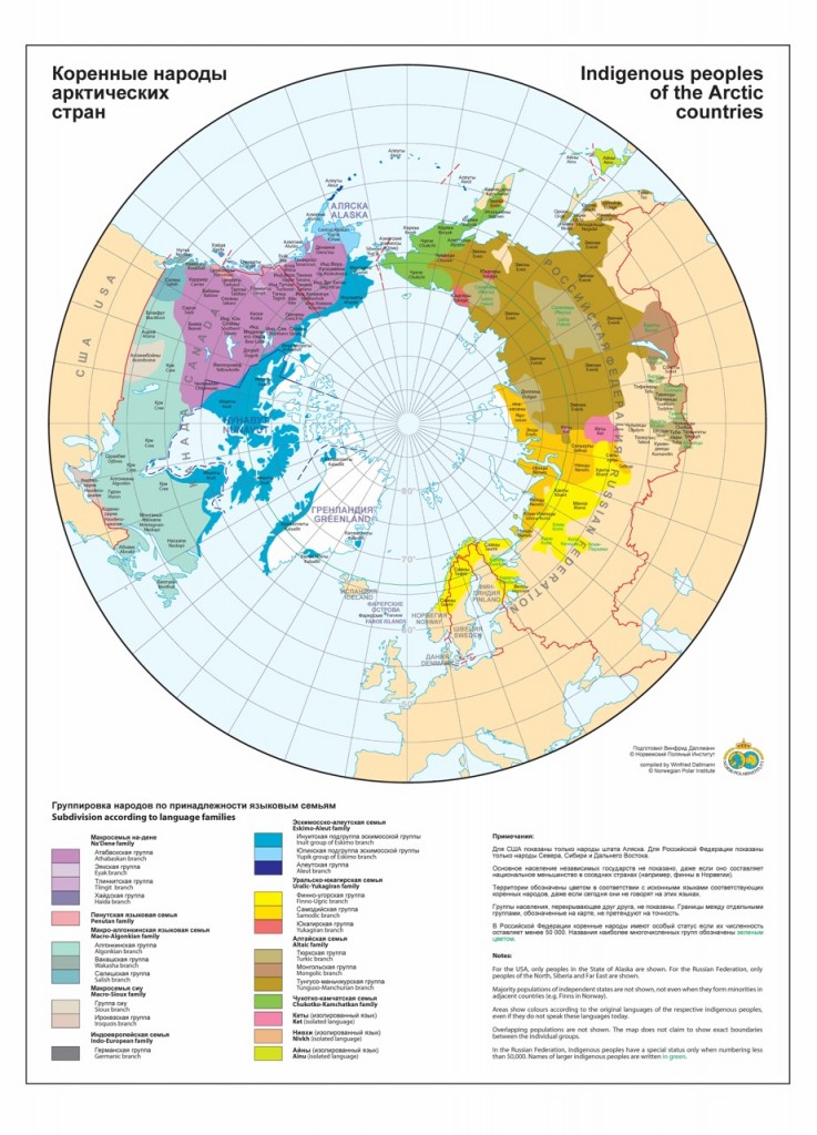
Thus, the stakeholders named by the Arctic Frontiers map are Iceland, the British Isles, Fenno-Scandinavia, Greenland, Nunavut, the Northern Territories, Alaska, Northern Europe, Eastern Europe, Siberia, and the Far East. There’s no mention of any of the Arctic 5 by name: the U.S., Canada, Norway, Denmark, or Russia. If we define frontiers to mean borders, the Arctic Frontiers map, then, is certainly charting new and unusual territories in terms of how the Arctic is conceptualized. The Arctic Frontiers map seems to closely correspond with the following map of indigenous peoples in the Arctic produced by Winfried Dallmann of the Norwegian Polar Institute. To paint a broad picture, there’s the similar tripartite division of Russia, the linking of western Greenland and Nunavut, the indivisibility of the “Northern Territories” and the widening of Alaska. One of the biggest differences between the two maps though is that in NPI’s version of the Arctic, Norway, Sweden, Finland, and western Russia are connected by a broad stroke of yellow representing the Sami people.
 Update: A reader has informed me that the map is based on the one used in the board game, Risk, and the black lines represent lines of attack or troop supply. Certainly an interesting inspiration given the emphasis we hear on cooperation and peace in the Arctic!
The map from “Risk.”
Second update: The map originally analyzed in this post was a draft. The post has been updated to reflect the conference’s usage of the final map, seen above. I apologize for my mistake.