
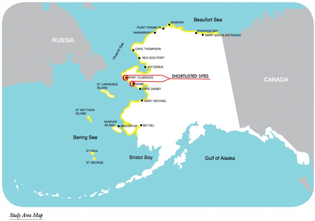
The 14 sites studied. – AK DoT and U.S. ACE (Shortlisted sites author’s addition.)
The State of Alaska’s Department of Transportation and the U.S. Army Corps of Engineers have just published a study on the best location for a deep-draft port in Alaska and the larger development of the state’s marine infrastructure. The “Alaska Deep-Draft Arctic Port System Study” supports investment in Alaskan ports for a number of reasons, including the rise in the number of ships sailing near Alaska’s coastline, 60 percent of which are foreign flagged. The area studied includes 3,000 miles of coastline, which the report states is an incredible one and a half times the distance of the lower 48s Atlantic coastline stretching from Maine to Florida. In this entire area, there isn’t one deep draft port, which must be at least 35 feet in depth to support icebreakers.
Constructing a deep draft port in northern Alaska would greatly improve the existing search and rescue situation. Currently, it takes the Coast Guard seven days to travel by cutter from the closest station, in Kodiak, to the northern edges of Alaska. A port could also assist with job creation, intra-state shipping, and even trans-shipment from Asia to Europe. The report mentions the possibility of resupply and fueling taking place at Dutch Harbor and Adak. Already, 3,000 vessels sail the North Pacific Great Circle Route annually, and 400 ships transit the Bering Strait each year, too.
The original 14 candidate sites were St. Paul Island, St. Lawrence Island, Nome, Port Clarence/ Teller, Kotzebue/Cape Blossom, Mekoryuk, Cape Thompson, Wainwright, Point Franklin, Barrow, Prudhoe Bay, Mary Sachs Entrance, Bethel, and Cape Darby.
The study used the following criteria to determine the most suitable port:
Nome and Port Clarence were shortlisted as the top two candidates. Nome (population 3,731) has an existing medium-draft port and is close to oil and gas and mining operations. There is also existing upland infrastructure.
Port Clarence (population 21) is 70 miles to the north via a seasonal road. It is a federal work site from which the Coast Guard operated LORAN (LOng RAnge Navigation), a radio navigation system for ships and planes, from 1961-2010. The site, sticking out far into the west on a spit of land, is close to the Bering Strait, and barges winter over there occasionally, waiting for the ice to melt north of the strait.
Below is a chart taken from the report showing the features of the top two sites. I find it somewhat disconcerting that oil spill response (OSR) capability is categorized as “Good” for each site, when actual capabilities are extremely limited, as this report from the Center for American Progress highlights in detail. OSR is not even defined in the report, though admittedly this is more of a preliminary overview than a detailed suitability study of the two shortlisted sites. In future studies, I’d like to see much more detail on infrastructure, both for shipping support, SAR, and OSR.
While the deep-draft port study includes many maps and tables, but sometimes what is as interesting as the ones that are included are the ones that are omitted. Here is the chart from the deep-draft port study:
| Nome | Distance from Outer Continental Shelf (OCS): MediumMining: GoodExisting Oil Spill Response (OSR): GoodCommunity Resupply: Very Good
Shipping Lanes: Good
|
Air Service: Scheduled jetRoad: Limited roadExisting Marine: Harbor | Regional Hub | Distance to -35 feet: <=1/2 mile Distance to -45 feet: >1/2 and <=1 mile | Ice Conditions: MediumOperational Considerations: Good |
| Port Clarence/Teller | Distance from OCS: MediumMining: GoodExisting OSR: GoodCommunity Resupply: Very low
Shipping Lanes: Very good
|
Air Service: Scheduled air taxi/ charterRoad: Scheduled Limited roadExisting Marine: Limited harbor | Minor Hub | Distance to -35 feet: <=1/2 mile Distance to -45 feet: >1 and <=2 miles | Ice Conditions: Medium`Operational Considerations: Good |
By contrast, here is a chart taken from the CAP report comparing Alaska’s oil spill response capability to that of the Gulf of Mexico, which the authors call “the ideal setting for oil spill response with its warm weather, highly developed roads, rail lines, and numerous major port cities.”
| Resources within 500-mile radius | BP Macondo well drilling site | Shell’s proposed Chukchi/Beaufort drilling sites |
| Airports with runways 8,000 feet or longer | 95 | 4 |
| Airports with runways 5,000 feet or longer | 347 | 13 |
| Equipment staging locations (oil spill response cooperatives) | 15 | 5 |
| Coast Guard permanent facilities | 30 | 0 |
| Major public ports | 35 | 0 |
Oil and gas operations are not just tangential to the construction of a deep draft port, for if the industry does in fact take off in the next few years or decades in the Beaufort and Chukchi Seas, there will be a lot more shipping activity. If a port is built, that could also make oil and gas drilling more feasible with the increase in infrastructure, response capabilities, and manpower.
The deep-draft port study recommends the usual recipe of strategic investment, environmental protection, and funding increases (in this case, to NOAA and other government agencies that carry out hydrographic surveys and bathymetric mapping). The report also suggests Public/Private Partnerships (P3) to help fund the construction of marine infrastructure. Whereas Russia generally builds all of its marine infrastructure using state funds, the use of P3 to fund infrastructure projects is more popular in Canada. To cite one example in the north, the federal government is contributing up to $77.3 million to the P3 Canada Fund for the Iqaluit International Airport Improvement Project, while a private partner has yet to be chosen to design, build, and operate the renovated airport. The study claims that P3s are now the main way by which container terminals specifically are operated. With ports offering multiple and distinct services (as opposed to say, a railroad station), including cargo handling, piloting, and towage, terminals are generally separated, with some operated by P3s and some remaining under the management of the government.
As a next step, more studies on topics such as weather, real estate ownership, and upland infrastructure will be carried out to determine the suitability of Nome and Port Clarence, so long as the Alaska Department of Transportation and the Army Corps of Engineers continue to share the costs of research.